About this app
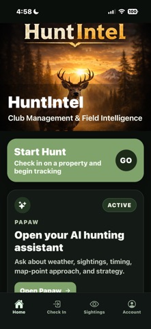
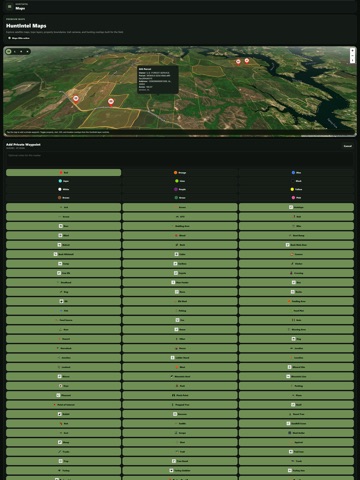
Eligible premium subscriptions include a 7-day free trial. Hunt smarter with AI-powered guidance, premium maps, terrain analysis, trail camera intelligence, and complete property and club management in one connected platform. Built for real hunters. Designed for the field. Veteran-owned. HuntIntel turns weather, terrain, sightings, trail camera images, and field activity into a clear hunting strategy. Whether scouting land, planning hunts, or managing a hunting club, HuntIntel helps you make informed decisions. AI Hunting Assistant Get practical guidance based on real field conditions. • Analyze seven-day weather forecasts by ZIP code • Compare the best days to hunt • Ask about deer and turkey movement • Receive wind-aware hunting and approach strategies • Use property, sighting, weather, and map-point context • Customize your AI Hunting Assistant’s name • Account for wind direction and weather when evaluating recommended locations and entry routes AI Terrain Analysis Turn property terrain into an actionable hunting plan. Select an existing property or draw a custom area of up to 2,000 acres. Choose whitetail deer or turkey, hunting times, and the terrain features you want analyzed. HuntIntel uses elevation, weather, and wind conditions to identify promising hunting locations and strategies. • Identify potential bedding areas • Locate saddles, benches, pinch points, and staging areas • Find travel corridors and entry paths • Compare morning, afternoon, and evening approaches • Save analyses and display recommendations as waypoints Trail Camera Analysis Upload images from virtually any trail camera and let the AI Hunting Assistant identify important details. • Identify species, sex, age class, and behavior • Review AI-generated image summaries • Connect images to trail camera waypoints • Discuss results with the AI Hunting Assistant Premium Maps and Land Intelligence Explore and understand your hunting ground with HuntIntel Maps. • View satellite, streets, topographic, and lidar basemaps • Use hillshade, slope, aspect, and Terrain Position Index layers • Overlay personal, club, and property boundaries • Add customizable waypoints with icons, colors, and notes • View properties in 2D or 3D • Use weather and terrain context while scouting Property and Club Management Manage personal hunting properties or coordinate an entire hunting club. • Create and manage multiple properties • Invite members and assign roles • Coordinate guests and approvals • Manage club rules and property settings • Connect properties to maps, reservations, sightings, and hunts Check-Ins and Real-Time Activity • Check in to specific properties • View active hunts across your club • Prevent overcrowding with property-level limits • Automatically check out based on club rules • Control how locations are shared Reservations and Planning • Reserve hunting properties or units • Prevent double-booking and conflicts • Review property availability before planning a hunt Sightings and Field Intelligence • Log wildlife sightings with location data • Record species, count, behavior, and notes • Add photos and track movement patterns • Share field intelligence with your club Weather and Conditions • View current property weather • Analyze seven-day forecasts by ZIP code • Track wind, temperature, precipitation, and conditions • Add selected forecast days to the AI Hunting Assistant Everything Works Together Maps, terrain analysis, weather, sightings, check-ins, reservations, trail cameras, AI guidance, properties, and club operations connect inside one hunting platform. One app. One platform. One hunting system. Stop guessing. Start hunting with a plan. Terms of Use (EULA): https://www.apple.com/legal/internet-services/itunes/dev/stdeula/
Latest release
What’s New
Version 2.2 focuses on two major improvements: Offline Maps and a cleaner, faster navigation experience, making HuntIntel even more useful in the field. New Offline Maps Take your maps into the backcountry—even without cell service. You can now: Download maps for offline use View properties, boundaries, and map layers without an internet connection Create, edit, and delete waypoints while offline Sync all waypoint changes automatically when you're back online Whether you're scouting remote areas or hunting where there's no signal, HuntIntel keeps working. Cleaner Navigation We've reorganized the app to make the features you use most easier to find. Navigation has been streamlined with quicker access to: Maps AI Hunting Assistant Terrain Analysis Check In / Check Out Reservations Sightings Club Management Account & Settings Help Center Improved Maps Maps now provide a more consistent experience online and offline, including improved waypoint management, cleaner layouts, and a smoother mapping workflow. AI Terrain Analysis Generate AI-powered terrain reports for properties or custom areas up to 2,000 acres. Analyze terrain for Whitetail Deer or Turkey and identify: Bedding areas Saddles Benches Pinch points Staging areas Travel corridors Entry routes Recommended stand and hunting locations Results are saved as map waypoints for future trips. Smarter Hunting Intelligence Continue using AI to: Rank the best hunting days from 7-day weather forecasts Analyze trail camera images Discuss sightings and scouting observations Build customized hunting strategies Club & Property Management Manage properties, hunting clubs, members, reservations, sightings, and check-ins from a more organized interface. HuntIntel 2.2 makes planning and hunting easier than ever with reliable offline maps, cleaner navigation, smarter AI, and powerful mapping tools—all designed to help you spend less time managing your hunt and more time hunting.
Audience growth
Ratings growth
Baseline captured. Growth appears after the crawler observes a changed rating count.
Momentum comes from crawler snapshots for the tracked storefront. “Viral growth signal” means unusually fast recent rating gains; it is an indicator, not download data.
Price tracking
Price intelligence
First snapshot captured. The trend line starts after the next crawler price observation.
- First observed Aug 19, 2026 · 10:17 AM Free
Screenshots