About this app
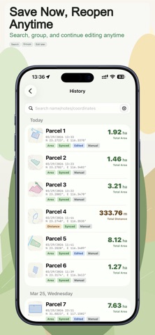
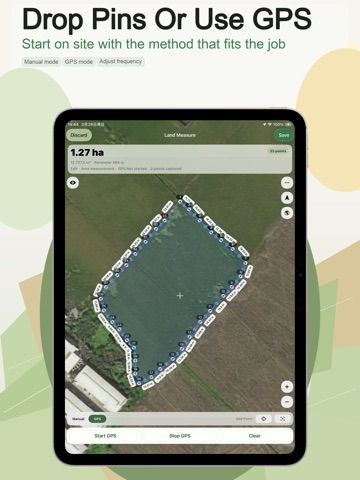
Some measurement apps can get you a number, but they fall apart after that. You finish the field work, then realize the record is hard to clean up, hard to find later, and hard to hand off. The goal is to make that workflow easier from start to finish. Use it to record three kinds of results on one map: - points for locations and coordinates - lines for route or boundary distance - areas for parcels, fields, lots, and sites You can collect points the way the job requires: - drop points manually on the map - walk the boundary and capture with GPS You can also keep editing instead of starting over: - drag points - insert midpoints - update length and area live - split polygons or cut holes for more complex parcel shapes Your records stay useful after the field work: - search, filter, and group history - open a detail view with map, metrics, coordinates, notes, photos, and export actions - continue editing an existing record and save it back to the same item Land Measure also supports file exchange for real work: - Export: KML, image, PDF, GeoJSON, Shapefile, CSV, DXF, TXT, GPX, Satloc(.job) - Import: GeoJSON/JSON, KML, GPX, CSV, TXT, DXF, JOB - Preview files before confirming an import It also supports multiple languages, metric and imperial units, and flexible coordinate formats for different regions and teams. Subscription Information - Pro is offered as monthly and yearly auto-renewable subscriptions - Pro unlocks more export formats, iCloud sync, and watermark-free image export - Payment is charged to your Apple ID at confirmation of purchase - Subscription renews automatically unless canceled at least 24 hours before the end of the current period - You can manage or cancel your subscription in your Apple ID account settings after purchase - Privacy Policy: http://suwenclub.cn/apps/mapmeasure/privacy-en.html - Terms of Use: http://suwenclub.cn/apps/mapmeasure/terms-en.html
Latest release
What’s New
- Screen stays awake automatically during measurement. - Optimized corner points during GPS measurement. - Other detail and stability improvements.
Audience growth
Ratings growth
Baseline captured. Growth appears after the crawler observes a changed rating count.
Momentum comes from crawler snapshots for the tracked storefront. “Viral growth signal” means unusually fast recent rating gains; it is an indicator, not download data.
Price tracking
Price intelligence
First snapshot captured. The trend line starts after the next crawler price observation.
- First observed Aug 18, 2026 · 2:03 PM Free
Screenshots