About this app
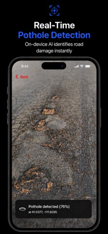
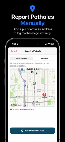
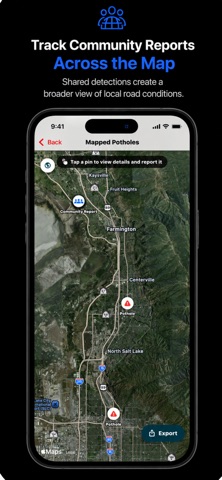
Pothole AI is an iOS app that uses artificial intelligence to detect, map, and report potholes using a smartphone camera. I created this project after becoming interested in how infrastructure problems can go unnoticed until they become more expensive, dangerous, and difficult to repair. Pothole AI was built around a simple idea: use AI to identify road damage earlier and make it easier to turn those detections into useful information. The app runs a custom-trained YOLOv11 computer vision model directly on the iPhone using Apple Core ML. This allows pothole detection to happen on-device without relying on cloud-based AI processing or external hardware. When a pothole is detected, the app can log its GPS coordinates, confidence score, timestamp, photo, and nearby address. Detections can be viewed on an interactive map and synchronized to a shared community map, allowing road damage reported from different devices to be viewed in one place. Users can also add potholes manually by entering an address or dropping a pin on the map. Pothole AI also helps users take the next step after finding road damage. For supported locations, the app can connect detections to existing government reporting systems. Where direct submission is not available, it can provide verified local reporting links or other relevant reporting information. Key Features: • AI-powered pothole detection • On-device YOLOv11 and Core ML inference • GPS-based detection logging • Photos, confidence scores, timestamps, and addresses • Interactive local and community maps • Manual pothole reporting by address or map pin • Government reporting integration where supported • CSV and PDF report export • Privacy-focused on-device AI processing Pothole AI is designed to complement existing road-inspection and public-reporting systems, not replace professional infrastructure assessment. Its goal is to make road-damage detection and reporting more accessible using hardware people already carry with them. More broadly, Pothole AI reflects my interest in building AI systems that can recognize real-world problems early and turn those detections into something practical and actionable.
Latest release
What’s New
Pothole AI 2.0 introduces major new features for detecting, mapping, sharing, and reporting road damage. • Shared community pothole map • Manual pothole reporting by address or map pin • Government reporting integration for supported locations • Photos, confidence scores, timestamps, and addresses for detections • CSV and PDF report export • Improved map controls and pothole detail views • Better camera session management and reliability • Expanded local reporting resources across Utah • General performance and UI improvements
Audience growth
Ratings growth
Baseline captured. Growth appears after the crawler observes a changed rating count.
Momentum comes from crawler snapshots for the tracked storefront. “Viral growth signal” means unusually fast recent rating gains; it is an indicator, not download data.
Price tracking
Price intelligence
First snapshot captured. The trend line starts after the next crawler price observation.
- First observed Aug 24, 2026 · 8:53 AM Free
Screenshots