About this app
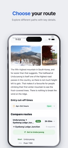
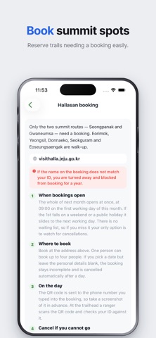
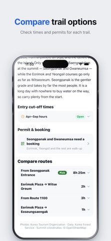
NOTE: This app is made by an independent developer. It is not affiliated with, endorsed by or operated by the Korea Forest Service, the Korea National Park Service or any other government body. Mountain information, trail closures and entry cut-off times are compiled from public open data. For official notices see Korea Forest Service Korea is mostly mountains, and nearly everything you need to settle before climbing one is published only in Korean. This app puts it in English: 146 mountains, including all 100 on the Korea Forest Service's famous-mountains list. It is not a trail navigation app — it helps you decide before you go, and gets you to the trailhead. ■ Compare the routes before you pick one A Korean mountain usually has several trails. The recommended route and the alternatives sit in one table, section by section, with how long each takes — straight from Korea Forest Service data. ■ What time do I have to start? Pick a route and the app works back from today's sunset: the latest hour you can set off and still be down in daylight. An hour of descent margin is already subtracted. ■ Trails close, and the notice is in Korean Wildfire-caution season — every spring and autumn Korea closes trails against fire, 106 of 569 national park trail sections. The app tells you whether today falls in that window and links to the Forest Service's closure map. Entry cut-off times — a national park trailhead opens at 04:00 or 05:00 and stops letting people in somewhere between noon and 17:00, set per trail, not per mountain. Cut-offs for 22 national parks and 363 control points are in the app. ■ Hallasan: what the official English page leaves out Jeju's Hallasan needs a booking on the Seongpanak and Gwaneumsa routes. Next month's slots all open at 09:00 on the first business day, the QR code goes to the phone number you type in, a no-show costs you three months of bookings, and a turn-back time on the descent catches people who made the entry deadline. With no Korean phone number, the English site's non-member tab verifies you by email — the Korean screen never shows that path. ■ Names that match the signs Outside the big parks, signposts are Korean only. Mountain names, districts and 1,347 waypoint names are romanized the way the signs spell them, and words that are not names are translated rather than transliterated — Summit, Junction, Ticket office, Shelter. ■ Stamp the summits The stamp only lands when your phone is actually on that mountain, and your count sits on the home screen. Titles rise with it, from Squirrel to Mountain God. Records stay on your phone — no account, no sign-in, nothing uploaded. ■ Getting there, and how hard it is Tap a summit pin and Naver, Kakao, Google or Apple Maps takes over with directions. Difficulty is the official grade where one exists, otherwise derived from the recommended route's duration — a rough guide. [Sources — every dataset this app uses] · Mountain details, routes and durations — Korea Forest Service, "Sup-nadeul-e: 100 Famous Mountains" https://www.foresttrip.go.kr · Route tracks (GPX) — Korea Hiking & Trekking Support Center, "KFS 100 Famous Mountains" https://www.data.go.kr/data/15125127/openapi.do · Photos — Korea Tourism Organization, "Tourism Information Service" https://www.data.go.kr/data/15101578/openapi.do · Map view and summit-coordinate verification — © OpenStreetMap contributors, ODbL https://www.openstreetmap.org/copyright · Wildfire-caution dates — Korea Forest Service https://www.forest.go.kr and Korea National Park Service https://www.knps.or.kr · Entry cut-off times — Korea National Park Service notices; Jeju Province for Hallasan https://visithalla.jeju.go.kr Wildfire-caution dates and entry cut-off times are compiled by this app from published material, not official notices. Always follow signs and announcements on site.
Latest release
What’s New
• Start time: opening the app before dawn answered with yesterday's sunset. It now answers for the day you are about to climb. • Summit stamps: only GPS taken on the mountain counts. When a stamp does not land the app now says why — location permission off, or no fix yet — instead of telling you to move somewhere with open sky. • Route comparison now opens on the recommended route instead of a summit map. • Entry cut-off lists fold sections that share the same hours into one line. Bukhansan was twenty identical rows. • Duryunsan: the description said you could ride the cable car down. You cannot — return tickets only, and the trail from the summit to the upper station is closed.
Audience growth
Ratings growth
Baseline captured. Growth appears after the crawler observes a changed rating count.
Momentum comes from crawler snapshots for the tracked storefront. “Viral growth signal” means unusually fast recent rating gains; it is an indicator, not download data.
Price tracking
Price intelligence
First snapshot captured. The trend line starts after the next crawler price observation.
- First observed Aug 19, 2026 · 5:55 PM Free
Screenshots