About this app
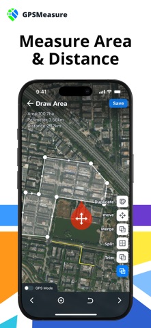
GPS Area Measure: Land Survey+ is a powerful iPhone measuring tool that helps you easily perform field area measurements, GPS distance calculations, and land surveying tasks—with instant sharing of results with your team. Whether you're measuring distances between objects, defining property boundaries, or calculating land areas with precision, this app offers professional-grade support. You can group your measurement results, categorize them with color labels, and manage multiple projects efficiently. It also allows you to add photos and notes to each measurement project for better documentation and organization. The app supports various units including square feet, acres, and kilometers, and is compatible with both imperial and metric systems—meeting a wide range of measurement needs. Key Features: ● Multiple Measurement Modes – Supports area measurement, distance measurement, and adding markers. ● Real-Time GPS Mode – Measure in real-time by walking or moving. ● Imperial & Metric Units Compatible – Use meters, acres, hectares, and more. ● Various Map Views – Land maps, field maps, and terrain views to enhance map accuracy. ● Advanced Measurement Design – Supports geometric operations across multiple areas, including trim, split, merge, copy, and move. ● Rich Color Grouping – Offers various preset color groups and custom group colors. ● Share Measurement Results – Export results as KML or GeoJSON files. ● Batch Management Mode – Efficiently manage your measurement results in bulk. ● Add Photos and Notes – Attach images and notes to your measurements. Why Choose GPS Area Measure: Land Survey+? ● High-Precision GPS Distance Measurement – Reliable land surveying results. ● User-Friendly Interface – Easy for both professionals and beginners to use. ● Share with Colleagues – Export measurements as KML or GeoJSON files. ● Easier Monitoring and Organization – Group, name, and add descriptions or photos to measurements for better identification and management. ● Convenient Marking Options – Manually mark points or use GPS mode for one-tap accuracy. ● Avoid Mistakes – Use accurate maps and marker points to avoid rocks, clearly define fences, or outline pasture boundaries. ● Cost-Saving – Complete measurements with your phone—no need for expensive surveying equipment. Who Is It For? ● Surveyors & Engineers – Conduct accurate land measurements. ● Farmers & Landowners – Measure and calculate property boundaries using land mapping tools. ● Construction Professionals – Plan field or room measurement projects. ● Outdoor Enthusiasts – Navigate with land mapping and GPS distance measurement. How to Use the App: Choose a Measurement Type – Area, distance, or marker. Draw on the Map – Use the interactive map or GPS mode to draw paths or areas. Save and Group – Quickly group your measurements. Batch Manage or Share – Manage multiple projects at once or share them with others. Subscription Information: Please note that to unlock features such as batch management, advanced editing mode, unlimited measurements, and color grouping, a premium subscription is required. We offer two subscription options: annual and weekly (with a free trial period). Unless auto-renewal is turned off at least 24 hours before the end of the current billing period, the subscription will automatically renew and the same amount will be charged to your iTunes account within 24 hours prior to the end of the current period. After cancellation, premium features will no longer be available once the current period ends. More Information: Technical support email: luoyouming@upluspace.com Privacy Policy: https://sites.google.com/view/upluspace-gps-measure-policy Terms of Use: https://sites.google.com/view/upluspace-gps-measure-terms
Latest release
What’s New
Bug Fixes and Feature Enhancements
Audience growth
Ratings growth
Baseline captured. Growth appears after the crawler observes a changed rating count.
Momentum comes from crawler snapshots for the tracked storefront. “Viral growth signal” means unusually fast recent rating gains; it is an indicator, not download data.
Price tracking
Price intelligence
First snapshot captured. The trend line starts after the next crawler price observation.
- First observed Aug 20, 2026 · 4:27 AM Free
Screenshots